
When determining the volumetric output and material stockpiles of a mining operation, accuracy and efficiency are the two most important factors of the process. Every cubic meter of material extracted holds value, and accurately measuring stockpiles is essential for effective resource management and logistical planning. Traditional methods of surveying and measuring stockpiles have often been labor-intensive, time-consuming, and susceptible to error. The integration of drones and Light Detection and Ranging technology (LiDAR) has transformed the landscape of stockpile measurement in mining into something more accurate, efficient, and safer.
Historically, mining companies have relied on manual surveying techniques, such as ground-based surveys, to assess stockpile volumes. These methods, while effective to some extent, were inherently limited in their precision and scalability. Ground-based surveys required significant manpower and time investment, often resulting in delays and inaccuracies due to human error and the challenging terrain of mining sites. That is where drones sporting precision LiDAR payloads come in to change everything about what we thought we knew about measuring stockpiles in mines.
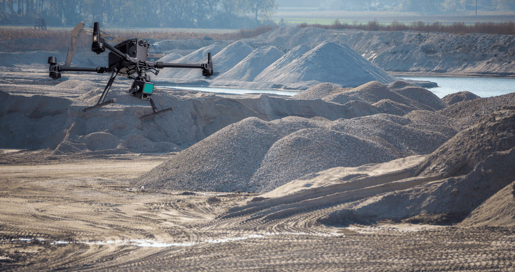
How Drones Improve Stockpile Measurement and Volumetrics
Drones, or Unmanned Aerial Vehicles (UAVs), have emerged as a disruptive force in various industries, including mining. Equipped with high-resolution cameras, GPS, and advanced software capabilities, drones have improved the way mining companies gather data and conduct surveys. In the context of stockpile measurement, drones offer several distinct advantages:
Rapid Data Acquisition: Drones can quickly navigate through mining sites, capturing thousands of images from multiple angles in a fraction of the time it would take traditional surveying teams. This rapid data acquisition minimizes downtime and allows for more frequent and comprehensive stockpile assessments.
Enhanced Safety: Operating in hazardous environments such as active mine sites pose risks to human assets. By deploying drones for surveying tasks, mining companies can mitigate these risks by keeping workers out of danger while still obtaining the necessary data for stockpile measurement.
Improved Accuracy: The high-resolution imagery captured by drones enables precise three-dimensional modeling of stockpiles. Coupled with advanced photogrammetry software, this data can be used to generate highly accurate digital surface models (DSMs) and point clouds, facilitating volumetric calculations with minimal margin for error.
LiDAR Drones Bring Enhanced Accuracy to Stockpile Measurements

(Stockpile volume calculation in Pix4Dmapper software – Image credit: GEO Jobe)
While drones equipped with photogrammetry cameras alone excel in capturing visual data, LiDAR technology complements their capabilities by providing depth information through laser scanning. LiDAR sensors emit laser pulses and measure the time it takes for them to bounce back from objects, thereby creating detailed 3D representations of terrain and stockpiles. The integration of LiDAR with drones offers several key benefits for stockpile measurement in mining:
Penetrating Vegetation and Obstructions: In environments where vegetation or other obstructions obstruct visibility, LiDAR can penetrate through foliage and debris to accurately map terrain and stockpile surfaces. This ability to see through obstacles enhances the completeness and accuracy of the data captured by drones.
Nighttime and Low-Light Operation: LiDAR sensors are not reliant on ambient light, making them perfect for nighttime or low-light conditions. This flexibility allows mining companies to conduct surveys around the clock, maximizing operational efficiency and minimizing downtime.
Sub-Centimeter Accuracy: LiDAR technology can capture data with sub-centimeter accuracy, ensuring precise measurements of stockpile volumes and surface profiles. This level of detail enables mining engineers to make informed decisions regarding resource allocation, inventory management, and extraction planning.
What Happens After Collecting LiDAR Data of Mines?

(Image courtesy of Virtual Surveyor)
The amount of data collected by drones and LiDAR sensors would be overwhelming without software tools to process and analyze it. Fortunately, advancements in photogrammetry and Geographic Information System (GIS) software have simplified the data processing pipeline, allowing mining companies to produce actionable insights from raw survey data with minimal manual intervention.
Software platforms like Pix4D and Agisoft Metashape enable the conversion of drone-captured images into dense point clouds, which serve as the foundation for creating accurate 3D models of stockpiles and terrain.
Specialized software applications, such as the LiDAR 360 Terrain Module, facilitate volumetric calculations based on the generated point clouds and DSMs. These tools automate the process of determining stockpile volumes and detecting any deviations from expected levels, streamlining inventory management procedures.
To fully leverage the insights gained from stockpile measurements, mining companies can integrate survey data into their mine planning and management systems. This seamless integration enables engineers to optimize extraction strategies, track resource depletion rates, and plan for future mining activities with greater precision.
In conclusion, the integration of drones and LiDAR technology in the mining industry has offered higher levels of accuracy, efficiency, and safety. By utilizing these aerial imaging and data collection tools alongside applicable software solutions, mining companies can streamline their operations, optimize resource utilization, and make informed decisions that drive sustainable growth and profitability. As drone technology continues to evolve, we can expect further innovations in surveying and measurement techniques, paving the way for a future where mining operations are characterized by precision, sustainability, and environmental stewardship from the sky.


