


GreenValley International Inc
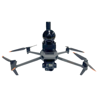
GreenValley LiAir Xmini (Power Version)
Request For Quote
Couldn't load pickup availability
GreenValley LiAir Xmini Power brings compact UAV LiDAR capture to powerline inspection workflows, enabling teams to collect aerial point cloud data for conductor classification, vegetation clearance analysis, and deliverable generation.
- Inspect powerline corridors from the air: Capture UAV LiDAR data for powerline inspection, conductor classification, and vegetation clearance analysis from compact UAV platforms.
- Deploy an integrated UAV LiDAR platform: Combine a lightweight LiDAR sensor, self-developed IMU, and integrated mapping camera in a single compact unit for efficient field deployment.
- Process powerline survey data: Use LiDAR360 compatibility to move captured point clouds into classification and powerline extraction workflows.
- Support vegetation clearance analysis: Process aerial LiDAR data through the GreenValley software ecosystem for forestry analysis and vegetation clearance workflows around powerline infrastructure.
Overview and Who It's For
The GreenValley LiAir Xmini Power is a professional UAV LiDAR system designed for powerline inspection, conductor classification, and vegetation clearance analysis from compact UAV platforms. It integrates GreenValley's lightweight LiDAR sensor, self-developed IMU, and integrated mapping camera into a field-ready package that pairs with LiDAR360 for end-to-end point cloud processing and deliverable generation.
- Forestry & Environmental: Supports vegetation analysis around powerline corridors using aerial LiDAR data and LiDAR360 processing workflows.
- Civil & Power: Supports powerline inspection, conductor classification, vegetation clearance analysis, and powerline extraction workflows.
What's Included
- GreenValley LiAir Xmini Power
FAQs
What is the GreenValley LiAir Xmini Power designed for?
The LiAir Xmini Power is designed for professional UAV LiDAR applications including powerline inspection, conductor classification, and vegetation clearance analysis.
What components are integrated into the LiAir Xmini Power?
The supplied product information lists a lightweight LiDAR sensor, GreenValley's self-developed IMU, and an integrated mapping camera.
Does the LiAir Xmini Power work with LiDAR360?
Yes. The LiAir Xmini Power is compatible with LiDAR360 for classification, terrain modelling, forestry analysis, and powerline extraction workflows.
Which UAV platforms are compatible with the LiAir Xmini Power?
Compatible UAV platforms are not specified in the supplied product information. Contact Candrone's Solutions team for available configuration and compatibility details.
What is the detection range of the LiAir Xmini Power?
The detection range is not specified in the supplied product information. Contact Candrone's Solutions team for detailed specifications and available configurations.
Warranty and Returns
This product is covered under the manufacturer's limited warranty. Candrone's standard return and exchange policy applies.
View Candrone's Warranty and Returns Policy
For warranty claims or support, contact our team at 1-888-461-5742 or visit our Contact page.
Get a Quote
Got a competing quote you want to beat or looking for a customized package. We'll put together an itemized quote for your review.
Schedule a Demo
See the GreenValley LiAir Xmini (Power Version) in action virtually or on-site. Contact our team to setup a demo.
Featured post

Understanding DJI Enterprise Care Service Plan (SP): A Guide for Buyers
Are you considering investing in a DJI Enterprise drone or accessories like the Matrice 350, Matrice 30T, Mavic 3 Enterprise, or Zenmuse L1? If so, you've likely come across the...